Paying my last respects to Staunton Mall…
7 minute read
December 14, 2020, 9:00 AM
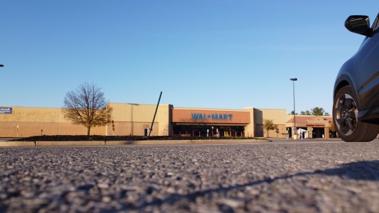
On a recent trip to Augusta County, Elyse and I stopped over at Staunton Mall to pay our last respects to the place. For those not familiar, Staunton Mall recently changed owners, and in late November, the new owners gave all of the remaining tenants a 30-day notice to vacate, except for Belk. The last day of operation for Staunton Mall will be December 24. So we stopped in and documented the place fairly extensively. Before I get started, please note that this Journal entry will be a very high-level look at the mall. I took over 1,200 photos of the interior and exterior of the mall, including at least one photo of every single storefront, and I’m going to give the place a more complete treatment as a photo set for Life and Times. But this ought to hold everyone for now, because the more complete treatment is going to take a while to put together.
The thing about photographing retail settings is that stores typically don’t like it when you photograph in their facilities. The usual reason cited is to protect trade secrets, which is usually bunk, because, as I understand it, a company has to put actual effort into keeping trade secrets a secret. If it is in plain view of the public, then it is not a trade secret. But that doesn’t stop stores from chasing off photographers. After all, it is private property, and they can choose to exclude whatever activities that they want. For my purposes, it just means that I have to be a bit more stealthy when I photograph, and shoot with my phone rather than with the big camera. The way that I typically operate when I do this is to go from lower risk to higher risk as far as getting caught goes. After all, once a place gets wise to me, the photo shoot is over, because they’ll never leave me alone again as long as I remain there. In this case, since I had the drone, I considered the aerial photography to be the least risky as far as getting caught goes, since I could accomplish that mostly from off of the property. Then after I finished flying around the mall, I photographed the exterior from the car with my real camera. Then I went inside the mall and did my documentation of the interior with my phone. I suspected that I wouldn’t have any issues with security personnel based on reports from others that there were no security people to begin with, and I was pleased that this ended up remaining the case. I’ve seen so many cases where stores and/or entire shopping centers are closing, and employees still get on people about photography. I can’t help in those cases but to think, why do you still care? After all, the people in question are losing their jobs soon, and so they’re continuing to defend their employer because… why? No matter what you do, at the end of the day, you’re still losing your job. So why are you still loyal to and defending a company that clearly has no loyalty to you? It doesn’t make sense to me.
Categories: Augusta County, Staunton, Staunton Mall
Going behind the pylons…
4 minute read
November 19, 2020, 11:31 AM
Back on November 6, Elyse and I took the drone out for a spin again, and I did some photography. This time, we went out to Leesburg, and took a late afternoon golden-hour flight around a familiar landmark: the former Walmart off of Route 15. This is a typical 1990s-era pylon-style store, and it closed in May 2019 when a new Supercenter opened elsewhere in the Leesburg area. Because of the proximity of the location to Leesburg airport, I had to notify the airport of our activity using their online form, and then, whirlybirds away. I flew up and around the building, and even investigated the roof a little bit.
Categories: Loudoun County, Photography, Walmart
Flying over the Shenandoah Valley with a drone…
10 minute read
October 25, 2020, 10:45 PM
Elyse and I recently made a trip down to Augusta County to see my parents, and we both photographed a bunch of stuff with my drone while we were down there. So all in all, we had a pretty productive time. I have gotten pretty proficient in flying my drone around things, and I’ve gotten some nice photos. The goal of the drone photography this time was to duplicate a lot of what I did in my earlier entry about the area in Microsoft Flight Simulator, but in real life. All in all, I had a good time, and I liked the results, as I flew around Staunton, Waynesboro, Afton Mountain, and Stuarts Draft.
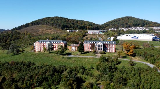
In Staunton, I first got aerials of the old DeJarnette Center, which is an abandoned children’s mental hospital that closed around 1996 in favor of a newer, more modern facility nearby. If this place sounds familiar, it’s because I’ve photographed it before. So here it is:
Categories: Afton Mountain, CFW, Family, Howard Johnson's, Photography, Staunton, Stuarts Draft, Walmart, Waynesboro, Woomy
Taking my photography to the skies…
7 minute read
October 6, 2020, 10:37 AM
I suppose that it was inevitable. When Elyse and I were out meeting up with someone in Baltimore back in March, they had a drone device that they used for a lot of aerial photography, and they showed it off to us. I loved that thing, a DJI Mavic Pro 2, and they gave me all of the information about it so that I could do my own research. I wanted one of those things, but I couldn’t justify a $2,000 price tag for a drone that nice when I had zero experience flying a drone, and didn’t have a good idea about what I wanted to do with it. So I sat on the idea for a while, occasionally going on Amazon to drool over the drone that I knew I couldn’t justify to myself. Then I found a somewhat lower-end drone, the DJI Mavic Mini. A $500 price tag was easier to justify, and that price also told me two things: first, it was expensive enough that it would do what I wanted it to do, but also cheap enough to be a good, accessible starter drone. I asked the experts on Reddit, and the consensus was that it was a good entry-level drone, and it could do everything that I was looking for it to do. So I went on Amazon and bought it.
One thing that I got a quick crash course in after I bought this was the regulatory environment for drones. Basically, you can’t just take this thing anywhere and fly it however you want. Like the roads, you share the airspace with other users, and as a drone pilot, in the big hierarchy of pilots, you are down where the dog lifts its leg. And that’s how it should be. I’m flying an unmanned vehicle, and as such, my feet are firmly on the ground at all times. If something goes wrong with my aircraft while I’m flying, the worst thing that happens is that I lose my drone, as well as all of the material that’s stored on the card. I might be unhappy about losing my drone and the photos stored on the card, but no one’s going to die should this thing fail mid-flight. Compare to a real pilot, who’s actually up in the sky with their aircraft, and if something went wrong there, there is a very real possiblity that someone could be seriously injured or lose their life. Therefore, I quickly learned that you have to do your homework before flying. Thankfully, there is a phone app called B4UFLY that will tell you what restrictions are in place in different areas. Right offhand, I live in the Washington, DC area, and as such, there is a lot of restricted airspace there, because Washington. In short, don’t even think about flying in DC, and you probably don’t want to fly in the suburbs, either. Right around my house, I also have restrictions because there’s a small airport (GAI) nearby. Once you get out of the immediate metro area, though, it’s fairly wide open, though national parks are a blanket no-go. But outside of that, there’s plenty of stuff to do.
Categories: Cameras, Frederick County, Montgomery Village
Reimagining how we elect our local officials…
7 minute read
October 1, 2020, 11:17 PM
There comes a point where you have to admit that a process is broken. In this case, I have reached that conclusion with the way that we elect the county council and county executive in Montgomery County, Maryland. Our current county executive, Marc Elrich, is the result of such a broken system. Elrich is a real stinker in my book for a number of reasons, and I admit that I didn’t vote for him in the primary or the general election, because I saw his being a stinker from a mile away.
But this entry isn’t about Elrich specifically. Rather, it’s about the process that brought him into office. And ultimately, the problem is that Montgomery County is using a bipartisan process for electing its officials when the county is overwhelmingly one party – Democratic, in this instance. The way that it works should be quite familiar to most of you: candidates of a given party run for office and compete in a primary election in the spring to determine who will be the nominee for the general election the following November, where all of the various parties’ nominees compete, and the winner of that contest takes office a few months later. Many, if not most, jurisdictions use this to choose their elected officials. However, it does depend to a large extent on having multiple viable political parties. It starts to fall apart when one party completely dominates the process, and none of the other parties’ candidates have a snowball’s chance in hell of ever being elected. In that case, the dominant party’s primary is the “real” election, and the general election is a formality. In other words, the result is already a foregone conclusion after the primary is done.
This situation is not unique to Montgomery County by any means. DC is similar, with the Democratic Party’s being the dominant political party over everything else to the point that the other parties don’t matter (save for an at-large council seat that is required to be a different party than the others), and the Democratic primary is generally considered to be the deciding contest for the mayoral race.
Categories: Montgomery County, State and local politics
Apparently, this happens to me once a decade…
6 minute read
September 20, 2020, 2:32 PM
Saturday night’s drive home was definitely a more eventful one than I would have preferred. Driving home from work (I currently work out of a division in Virginia), I tend to take Route 267 to the Beltway to I-270 and then to Route 355 (i.e. Rockville Pike) on my way north to Montgomery Village. The details in MoCo tend to vary depending on my mood. Sometimes I take 270 all the way to Shady Grove and cut over there, and sometimes I get off lower down and do more travel on Rockville Pike. Saturday night was the latter, where I got off on Democracy Boulevard and took Rockville Pike all the way from North Bethesda to Gaithersburg.
At the intersection with First Street (the one with the CVS and the Wendy’s with the glass sign), I was sitting at a red light in the middle lane, and I saw a car run the red light at a high rate of speed in the right lane. They were going quickly enough that I could feel their wake as they went by (and I felt them before I saw them). Then a few seconds later, just as the light turned green, a Maryland state trooper went past me, again at a high rate of speed, with lights off, to my left. I kind of assumed that they were related, and that I would see the trooper pull the other vehicle over at some point on my way home. So I had my eyes peeled, as I expected to see blue lights at some point.
Then, just before the intersection with Mannakee Street, a deer darted out in front of me, and with not enough space to swerve to avoid and not enough distance to stop, we made contact. I remember screaming as we hit, and I saw the deer sort of stagger away. I stopped the car immediately, right there in the center lane. I got out, looked at the front of the car, and saw a brand new hole where the grille used to be, pieces of the front of the car sticking out of the front, as well as bits and pieces of the Honda logo on the road. Then, realizing that the engine was still running, and seeing nothing dripping out from underneath, I moved the car to the parking lot of Cameron’s Seafood, and after letting Elyse know that I would be delayed, called 911 to report the accident. Surprisingly, 911 told me that for a deer strike, they weren’t going to send an officer to take a report, and just to follow up with the insurance.
Categories: Driving, Honda HR-V (2018), Rockville
Flying over the Shenandoah Valley…
8 minute read
August 27, 2020, 11:25 PM
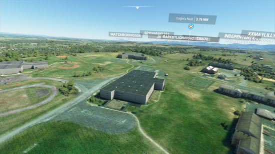
Recently, Elyse got a copy of the new Microsoft Flight Simulator game, which, among other things, features real landscapes based on map data. However, it’s not without its issues, since, if it doesn’t have good data for buildings and such, it attempts to fill in the gaps by rendering a building, taking a guess as to what kind of building it’s supposed to be. When there is good building data, the buildings look correct, as is the case in much of Howard County, Maryland. Down in Augusta County, that’s not the case, and most of the buildings are rendered by the game, doing its darndest to make a good guess. To accomplish this evening’s field trip, Elyse dropped us at Eagle’s Nest Airport, which is a privately-owned airport just outside Waynesboro. I didn’t have to fly the plane. Rather, we left the plane on the runway, and just flew around with the camera. I didn’t want to have to fly an airplane, after all. I just wanted to have a little eye in the sky. So from Eagle’s Nest, I quickly got my bearings, and made a beeline to Stuarts Draft.
First thing that I took a look at was my old middle school, Stuarts Draft Middle School:
Categories: Afton Mountain, Harrisonburg, Staunton, Stuarts Draft, Video games, Waynesboro
A paint job for the living room…
10 minute read
August 21, 2020, 11:30 PM
Surprisingly, I never posted about the repainting project that I did in the living room, but better late than never, I suppose.
In any case, I embarked on a massive painting project last fall and winter that transformed the living room and hallways into something that looked the way that I wanted, rather than something that previous owners might have wanted. The project was something that I had planned from the outset upon moving in because, while I didn’t necessarily dislike the color of the living room and the hallways, the paint, depending on the location, was either in poor condition with a lot of old nail holes, or, in the case of the upstairs hallway specifically, never painted well to begin with. So rather than try to match the color, it made far more sense to just repaint the whole thing in a new color of my choosing.
In planning this project, I had to figure out how to make my living room look its best. My living room is long and narrow, and only has one window at the front. So most of the lighting would come from artificial sources, such as the overhead lights and the lamp. I ultimately decided to go with a sunnier color than what was there before on three sides, and then I also put a dark blue accent wall on the left side. That left wall is completely blank, which made it a good candidate for an accent color, since I could do just about anything that I wanted with it as far as furniture arrangement and decor went. I extended the new color up and down the stairs, since I found the transition between the tan living room and white stairs to be a bit jarring. Extending the living room color up the stairs and down to the basement just made sense.
Categories: House, Montgomery Village
Some sad looking retail…
6 minute read
August 9, 2020, 11:44 AM
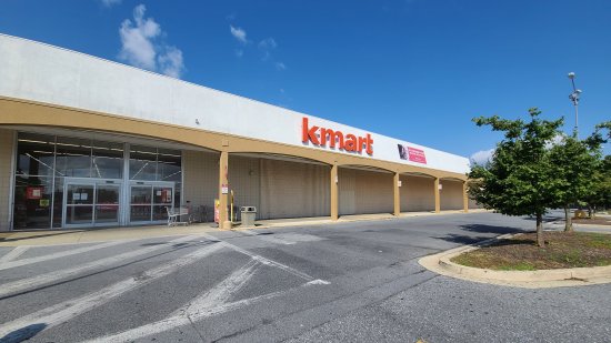
On Saturday, Elyse, Aaron and Evan Stone, and I went out and visited the Kmart store in Aspen Hill, and the Sears store in White Oak. The last time that I had been to either of these stores was in 2017, well before the Sears bankruptcy. I had heard on social media about the way that the remaining non-closing Sears and Kmart stores were being merchandised, and I felt like it was time to see it for myself. What I saw was what I more or less expected based on what I saw online, but definitely not what someone might expect for a retail business that is still a going concern.
We first visited the Kmart on Connecticut Avenue, which is located less than a mile away from my old apartment on Hewitt Avenue. I knew this Kmart well enough, though I was never a regular there by any means. This is also the last Kmart in Maryland to remain a going concern, as the store in Edgewater is currently conducting a store-closing sale, and all of the other Kmart stores in Maryland are gone.
This is the state that the Aspen Hill store was in:
Categories: Companies, Elyse, Friends, Retail, Silver Spring
Drive carefully, everyone…
3 minute read
May 17, 2020, 12:21 AM
You may have noticed the photo feature that is currently running on the front of the site depicts a vehicle on its side following its being involved in an accident. First of all, before you ask: we were not involved in this accident. Elyse and I saw a car with a bashed in front in the middle of the road and a second car on its side at the intersection of Montgomery Village Avenue and Lost Knife Road while we were on the way home from dropping off a package at a UPS locker, and, seeing no emergency vehicles around, stopped and called it into 911. Thankfully, no one appeared to be seriously hurt, as both drivers were able to walk away from their respective vehicles. However, I suspect that the driver of the smashed car hit her head on the windshield, as there was damage to the windshield consistent with that sort of impact. Additionally, both drivers did ultimately leave the scene in ambulances, presumably to get checked out.
Once we were finished talking with 911, we got some photos of the scene. Here are some of mine:
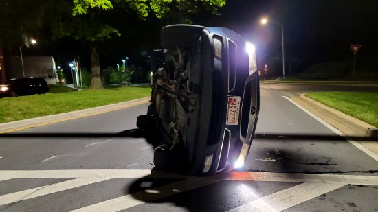
The overturned vehicle, an Acura MDX. The driver had not yet turned the car off when this photo was taken.
Categories: Driving, Montgomery Village
Photographing a very large plane…
3 minute read
May 12, 2020, 11:30 PM
Today, Elyse and I headed up to BWI in order to photograph an Antonov An-124 Ruslan that was coming in for a landing. For those not familiar, Antonov planes have helped transport various medical supplies to where they are needed in the fight against the coronavirus. As I understand it, these movements are generally not publicized in advance, but the plane shows up on various aviation tracking apps, and as such when one is found, people tend to head out to spot them. Elyse let me know, and after I warmed to the idea (I don’t take too kindly to requests for adventures before I even get out of bed), we went up to the aircraft observation park (we’ve photographed here before) to await it.
When we got there, there were a bunch of guys with cameras that had really big lenses, as well as radio scanners. Then the winds shifted, and the planes started landing on another runway that is not very visible from the observation park. All of the guys with the big lenses then left and headed to a nearby Royal Farms, which is an excellent vantage point for the other runway. We followed them, assuming that they knew what they were doing. Then after we got there, we saw all of the guys head back to the observation park, and we followed. And then the plane, tail number RA-82042, came through:
Categories: Airplanes, Anne Arundel County, COVID-19
A trip out to Hampton Roads…
18 minute read
April 19, 2020, 10:15 AM
From April 3-6, Elyse and I made a trip to the Hampton Roads area of Virginia to visit friends and do some photography. The way I figured, the trip was already paid for, and so as long as we took adequate precautions, I saw no harm in running it as planned. After all, I go out every day to go to work transporting the public, so it’s not like we were “breaking quarantine” or anything, since I’m out in the environment on a regular basis throughout all of this. All that said, if you don’t like that we took this trip, keep it to yourself, because I don’t want to hear about it. On our trip, we stayed in Williamsburg, and had a fun time, mostly photographing architecture and infrastructure with friends Aaron and Evan Stone.
Meanwhile, leaving the house, I had the worst shotgun passenger ever:
I mean, despite his sour disposition, you really didn’t think that we’d take a trip without bringing Woomy along, did you? Elyse quickly threw him out of the front seat so that she could ride, and so Woomy rode in the cup holder.
Categories: COVID-19, Hampton Roads, North Carolina, Richmond, Roads, Ships, Transit, Travel, Woomy
Stack ’em up?
7 minute read
April 1, 2020, 1:25 AM
So my latest experiments with photography have been with stacking exposures. For those not familiar, the general idea behind stacked exposures is to take several short exposures instead of one long exposure, and then “stack” them on top of each other in order to simulate a photo with a longer exposure. It is useful in situations where a true long exposure is impractical, such as when shooting in daylight. The way it’s done is that you take all of the shots that you intend to stack out in the field, preferably using a tripod and a remote control for the shutter, and then do the stacking at home.
Whenever I test a new technique, I typically will shoot photos of something that I’ve photographed before. This way, I already know what the photo is supposed to look like, and I know what works as far as angles go. That eliminates a few variables so that I can just focus on the technique. In this case, I did two field trips. One was out to Point of Rocks and along Route 7 in Virginia and ultimately into DC, and the other was to Burnt Mills Dam off of US 29 in Montgomery County. The Virginia trip was mostly for nighttime shots, and the Burnt Mills trip was for daytime shots.
At Point of Rocks, Elyse went trainspotting at the nearby MARC station while I wandered around with my tripod to photograph some stuff. My focus was on the Point of Rocks Bridge and the Potomac River running under the bridge. My focus was mainly on smoothing out the water.
Categories: Frederick County, Loudoun County, Montgomery County, Photography, Washington DC
The signs of social distance…
7 minute read
March 28, 2020, 12:40 AM
In the era of social distancing brought on by the novel coronavirus, I have definitely observed some changes in how the world looks. As a person who works in an essential industry (people still have to go places, yo), I still get out quite a bit. In my work, service levels have been reduced, and all trains are now eight cars in order to allow people to space themselves out, plus it’s strange to go through some stations in the middle of the day and pick up nobody. It’s also strange seeing the message boards on the Beltway advising people in big letters to stay home. It’s also strange to see so many people wearing gloves and surgical masks, even though those don’t do anything when the general public wears them as a preventative measure, and may actually be harmful if the person wearing them thinks that it excuses them from things like not touching their face, washing their hands, and so on.
In any case, most of the time when I’m going out, it’s to pick up a few things at stores, mostly on my days off of work. The first thing that I noticed was the panic buying, as seen on March 14 at the Target in Rockville:
Categories: COVID-19, Fairfax County, Loudoun County, Montgomery County, News
Fun in Pennsylvania…
8 minute read
March 7, 2020, 10:00 AM
I guess that you could say that my March came in like a lion. On March 1 and 2, Elyse and I did an overnight trip to south-central Pennsylvania, a 350-mile journey that took us to an abandoned motel, to Breezewood, through three of the four mainline tunnels on the Pennsylvania Turnpike, to Harrisburg, and then back home. All in all, we had a fun time.
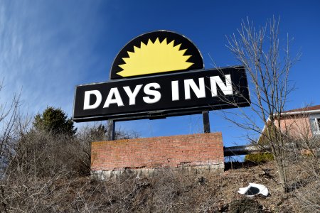
Our first stop was the aforementioned abandoned motel. This was a former Days Inn near Breezewood, and from what we could tell, it had been abandoned since 2013, and, from the looks of things, it will never be occupied again. Just about every piece of glass in the place had been shattered, the ceiling in the hallways had either fallen down or been pulled down, and there was mold everywhere. Lovely place.
Categories: Breezewood, Harrisburg, Travel, Urban exploration


 Continue reading…